Ralston, PA is a small town nestled in the mountains along the Lycoming Creek, some 30 miles north of Williamsport. Ralston was an important crew-change point and helper station along the PRR’s Elmira Branch until the late 1920’s. The town’s importance to the PRR declined after this time, as larger, more powerful locomotives were developed that could make a through run from Tyrone or Altoona to Southport yard in Elmira, NY in a 16 hour crew day, obviating the need to exchange crews that were about to “outlaw” on hours-of-service for rested crews that had been stationed in Ralston. For a more detailed look at PRR activities in Ralston, see the excellent book “Set Up Running – The Life of a Pennsylvania Railroad Engineman” by John W. Orr. The book also includes a map of Ralston and the PRR facilities there.
Ralston was relatively less important to the SNY, but was served by a short branch from Marsh Hill yard. A large tannery, operated by the Elk Tanning Company, was located there. I have heard from other sources that there were several other smaller industries in Ralston in the early and mid-20th century, most notably a brick yard and a baseball bat factory, but I have no hard sources for that information.
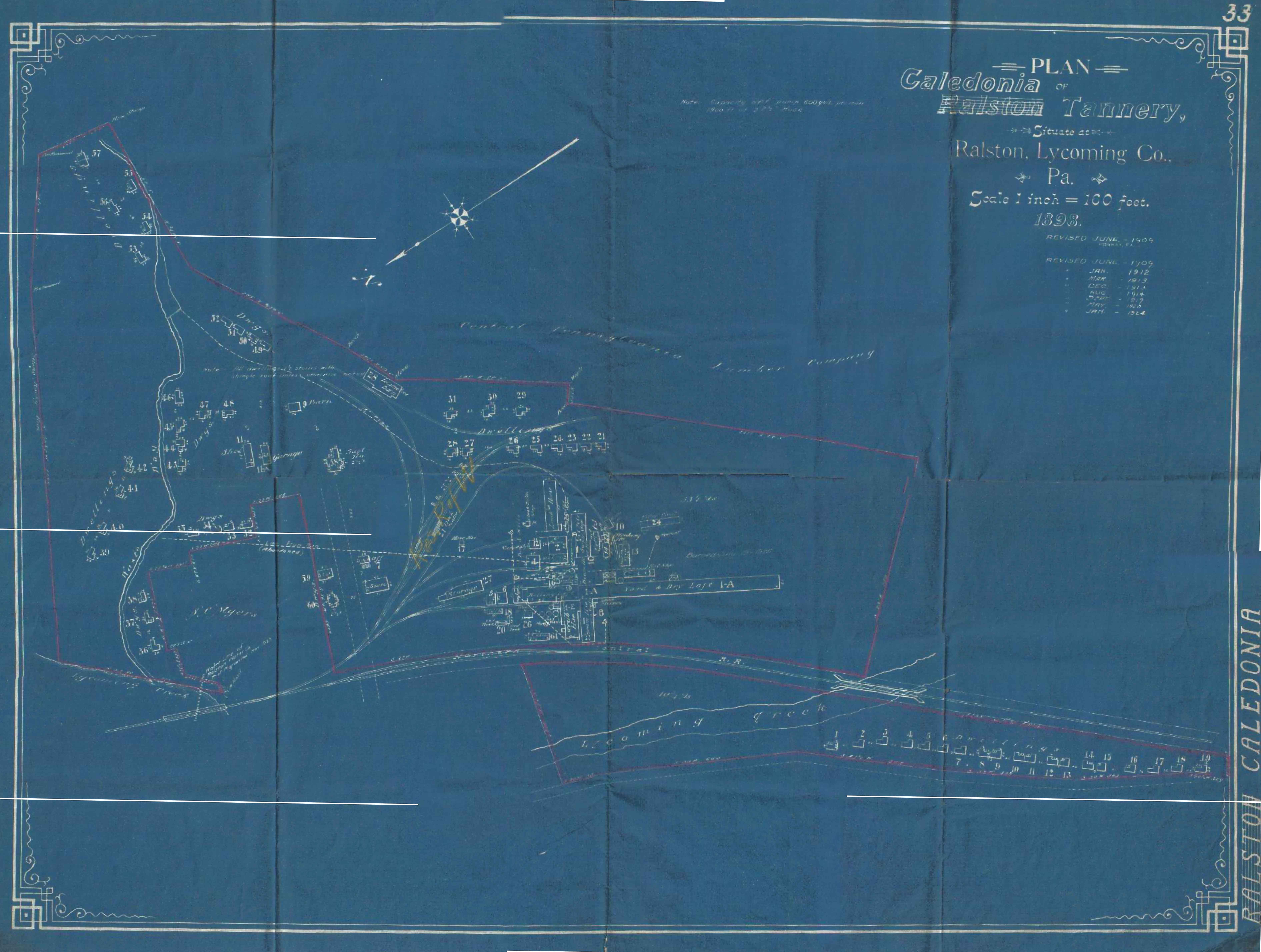
Map Courtesy Roy Breon via the “Elmira Branch” Yahoo Group
Above is a scan from a valuation map of Ralston posted to the “Elmira Branch” group on Yahoo. This map dates from 1898 (with periodic revisions noted, the last dated 1924), prior to the existence of the SNY. The SNY did not come into being until 1902, and did not reach its western terminus at Ralston until September 1903. It can be assumed that the tannery was probably served by the Northern Central Railroad (precursor to the PRR in this area) prior to the arrival of the SNY in 1903. Indeed, part of the impetus for completion of the SNY was to service tanneries owned via various corporate entities by the United States Leather Company. Most of the timberland along the SNY route was owned by the Keystone Lumber Co., another subsidiary corporation of US Leather; and the SNY railroad itself was owned ultimately by the US Leather Company as well. This large conglomerate most likely did not want freight revenue to “leave the family”, so to speak; so why not build its own railroad to capture the revenue instead of paying the Northern Central.
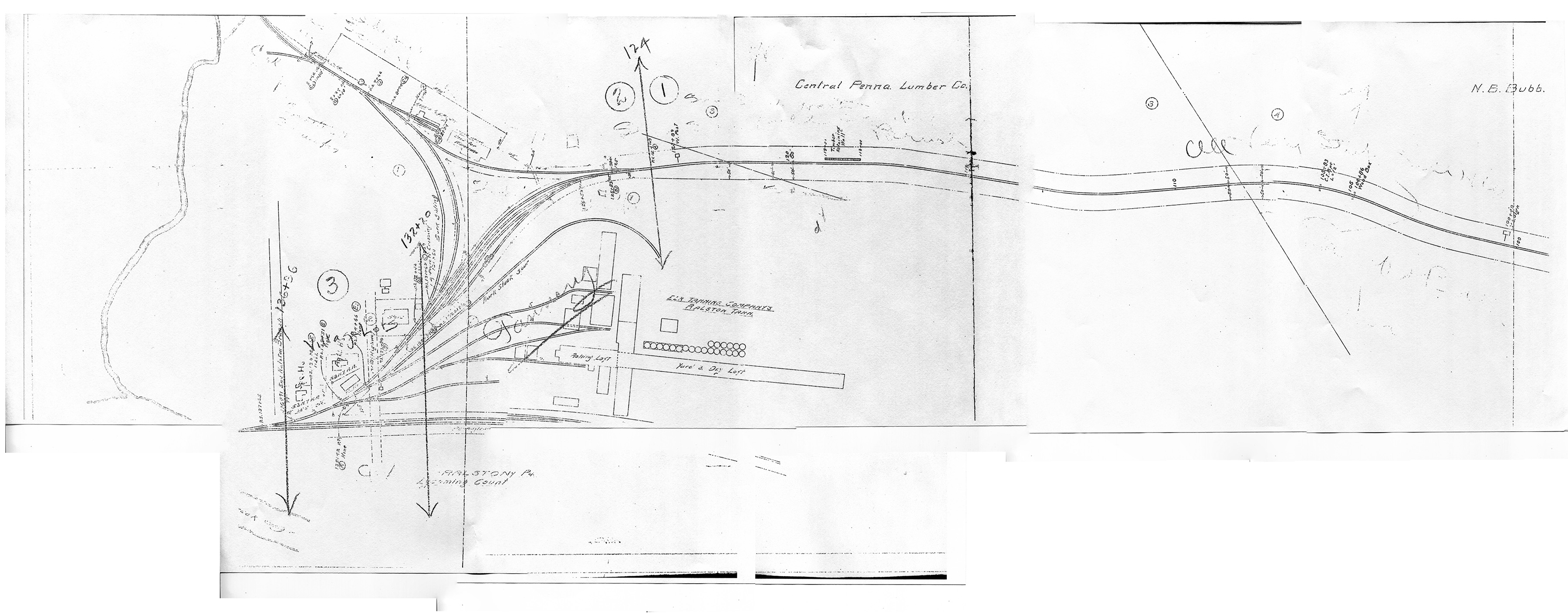
Map Courtesy of Charlie Marvin
Above is a valuation map, circa 1918, provided by Charlie Marvin. North is to the viewer’s left. We can now see by this time that the SNY enters the area from the south along Lycoming Creek. However, the western terminus of the SNY is no longer at Ralston, as the railroad decided to construct a new yard and engine service facilities further south at Marsh Hill as part of the railroad’s plans to expand south to connections at Newberry, PA. However, there were still a few customers to be served in Ralston, and the SNY ran local trains up the branch from Marsh Hill to service them. I believe I had read in one source that the tannery had burned down by the mid-1920’s and was not rebuilt, as the hemlock bark used in the process had been pretty much exhausted from the area forests, all the hemlock having been timbered. One of these industries was apparently a “wildcat” coal mine that produced a few cars a week. The struggle the SNY had to get cars upgrade to this mine is described vividly in “Set Up Running”. I believe most of this coal was probably used as locomotive fuel by the SNY itself, and not much was likely interchanged offline.
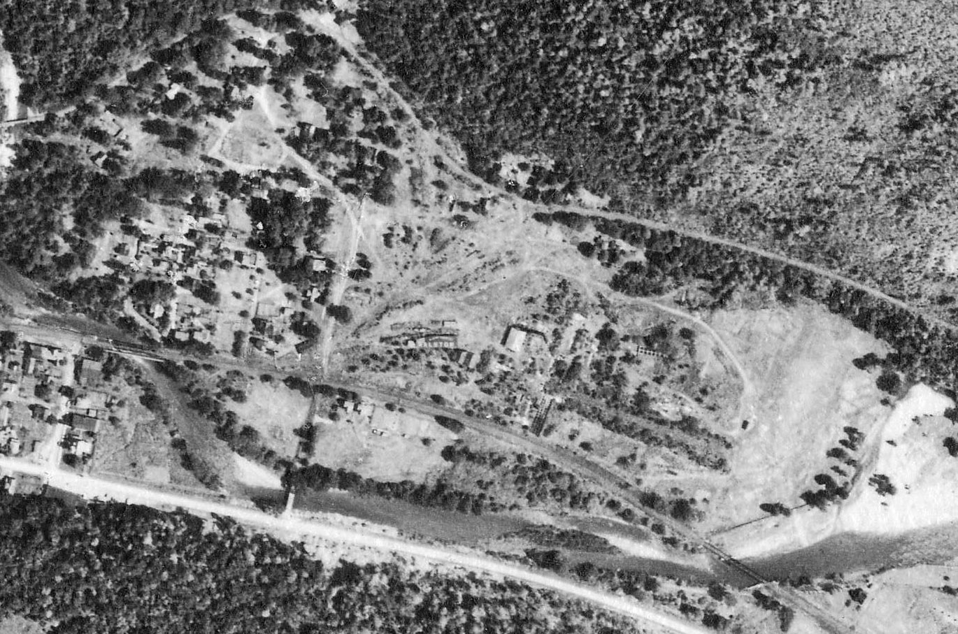
Penn Pilot – Penn State
Above is a 1938 aerial view from Penn State’s Penn Pilot site. I have cropped and rotated the original to match the valuation maps above. We can see the SNY branch to Marsh Hill heading off to the viewer’s right, and the SNY wye, and remains of the tannery buildings in the center. At the lower center is the PRR Elmira Branch running right to left, with two bridges crossing Lycoming Creek at the middle and south end of town.
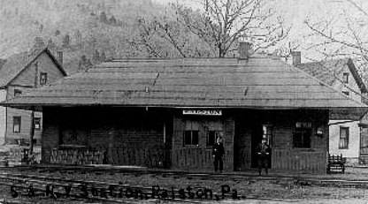 Above is a poor quality scan from the ‘net of the SNY station at Ralston. This is the only photo of SNY structures in Ralston I have come across. I believe it was probably located at the north end of the SNY wye trackage, near Lycoming Creek and the Northern Central (later PRR).
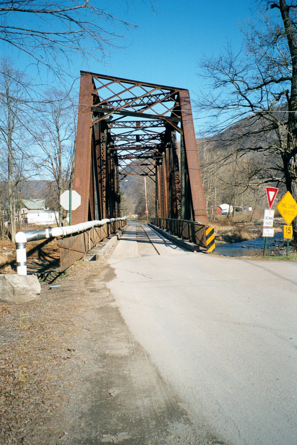
Photo by Author
Above is a view looking northward, of the second of three PRR bridges in Ralston (At the viewer’s left lower center in the 1938 aerial view above). This bridge survived the flooding during Hurricane Agnes in 1972, but was abandoned by Penn Central since the flooding wiped out many of the branch’s other Lycoming Creek bridges. Later taken over by the town of Ralston and used as a road bridge after more floods in 1996 destroyed the nearby road bridge, it was finally removed in 2002 after a modern concrete road bridge was built by the county immediately adjacent.
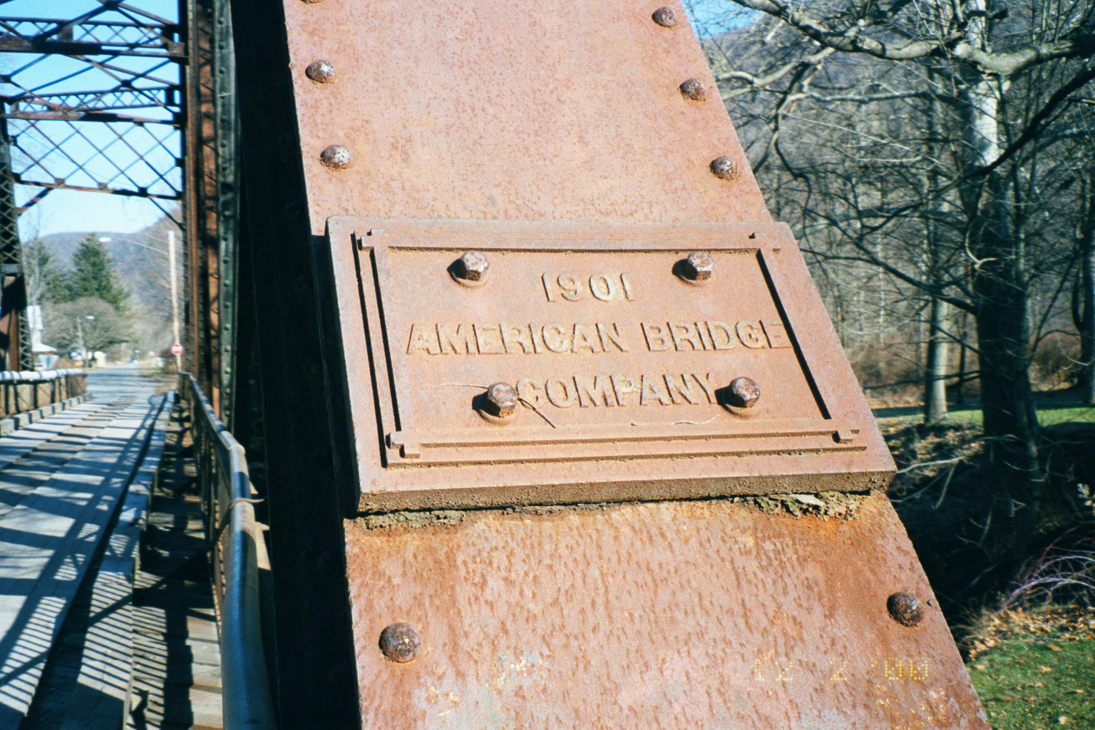
Photo by Author
Detail view of the bridge, built in 1901. Ironic to note that this bridge actually dated to the Northern Central Railroad era, and pre-dated the arrival in Ralston of both the PRR (the NC was not completely absorbed by the PRR until 1917), and the SNY (which did not arrive until 1903), yet outlived them both.
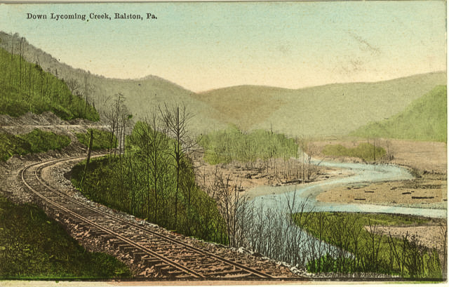 Above is a scan of a postcard view of the Lycoming Creek valley near Ralston from the early part of the 20th century. Aside from the size of the trees, Lycoming Creek in most spots does not look much different today.
Google Earth
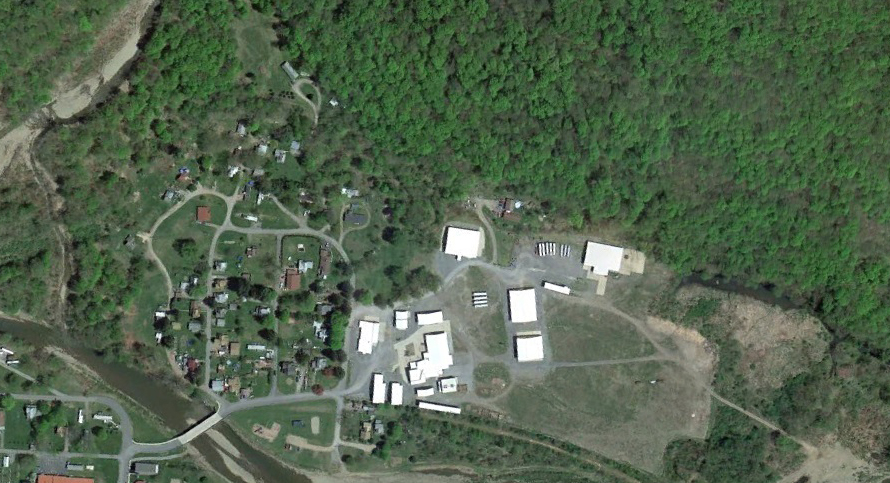
Lastly, above is a modern satellite view of Ralston from Google Earth, again oriented with north to the viewer’s left . The modern bridge which replaced the hundred year-old Northern Central bridge can be seen in the lower left corner, and is just downstream from the site of the old bridge. A modern wood-products plant is sited on the footprint of the old tannery. Time, floods, trees, and newer construction have pretty much obliterated any trace of the SNY, though the old Elmira Branch roadbed can still be faintly seen curving just west of the new factory.
Update 11/29/13:
Reader George Lane provided a link (http://www.loc.gov/pictures/item/2008677185/) to a stereoscopic view of the Northern Central station at Ralston ca. 1870 from the Library of Congress. I would guess the view is looking north with the northern-most of the three bridges over Lycoming Creek in the background. I am not sure of the identity or precise location of the colonnaded building in the background:
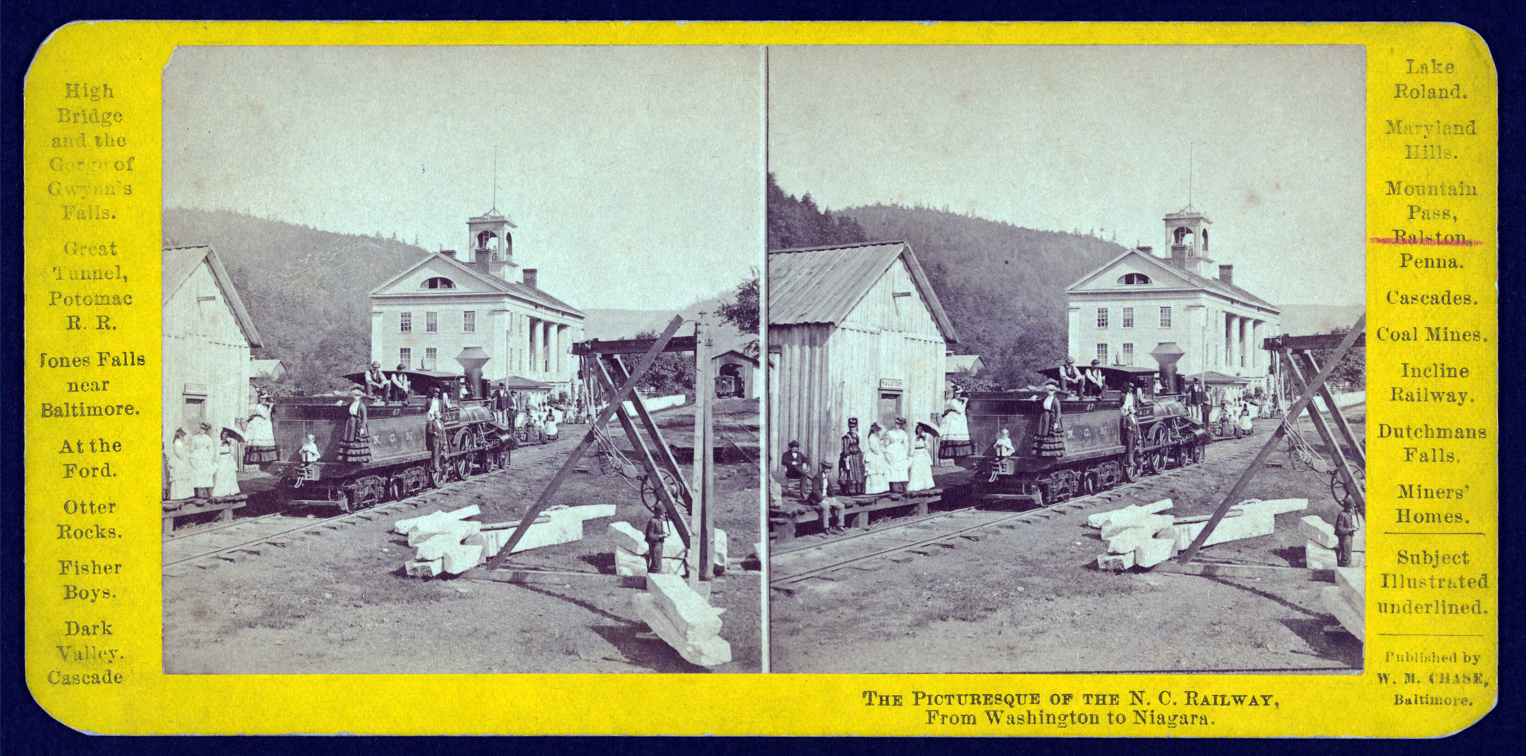
Library of Congress
My understanding is that the SNY line to Ralston continued to “McIntyre” where the inclinded plane came down the mountain and coal was loaded in cars. I have chosen not to model Ralston (space again) except for the junction switch and the very end of the branch line where I have a tipple created strictily from my imagination.The SNY also handled coal from interchange at Marsh Hill from the Pennsy and some from the NYC in Williamsport as “supply coal” for the LV at Towanda. So some hopper traffic over the hil is prototypical.
I’m not sure how that would have worked though, as the map in “Set Up Running” shows the coal tipple on the west side of the Northern Central. A photo in Gunnarsson’s book looking down the plane seems to confirm this. The SNY would have to cross over the Elmira Branch to get to it.
Somewhere I have a note from someone that stated the SNY interchanged about 30 cars a week of steam coal to the LV at Towanda. I plan to incorporate this overhead traffic on my model SNY, and I have the Bowser and Accurail cars to support it, although they are still mostly in boxes…
Sorry to take so long in reply, but some eye surgery has slowed me down. The overhead coal traffic is a boon to operations and will step up the number of trains running, thanks for the info.
There is an 1855 map in Bradshaw Mtn.- a History (P. 34) that shows a branch from Ralston to “McIntyre (mines)” all on the east side of the NC main. It is found on p.34. This would preclude the necessity of a crossing. It looks like the plane was at a different location than “McIntyre”. Somewhere I read that the SNY used a side hill “pick and shovel” coal source, although I am providing a tipple (which I’m sure will be appreciated by the miners, 8<)).
The Northern Central Railway had a set of stereographic prints showing the scenes on their route from Washington DC to Niagara Falls. The Library of Congress has one image in the digital archives of the NC RY at Ralston PA. You might want to add it to your excellent web page,
http://www.loc.gov/pictures/item/2008677185/
George,
Done! Thanks for the link.
Correction on information regarding the picture of the 2nd railroad bridge in Ralston. This was abandoned after the Agnes Flood in 1972 but was not used for vehicle traffic until after the Jan. 1996 flood when the bridge for vehicle traffic which was at another site was destroyed. The railroad bridge was removed after the new modern bridge was built by Lycoming County 6 years later in 2002.
Betsy,
Thanks for the info; corrections made.
I grew up in Ralston; 1940’s. In my browsing today I see the photo of the SNY station in South Ralston. We lived in the house next to Spenser’s just to the right of the photo. Christiansen’s house is the big one in the center background. The SNY trains would come screeching along the Sullivan hill-side by Lootie’s house (chicken and eggs) and eventually cross the trestle over Rock Run. Many an exploring trip walking across that trestle. The footbridge to “uptown” was adjacent to the railroad bridge. The Conley(sp?) house was on the north side of the bridge. Lots of days fishing off the footbridge. Now I’m looking for info on Langdon Lodge IOOF #?. My father was very active with that group. So many wonderful memories.
In John Meginness’s 1892 History of Lycoming County he describes the building of what was intended to become a great hotel in the town of Ralston. It was the original Ralston House and I believe that is the original name of the colonnaded building in the background.
http://www.usgennet.org/usa/pa/county/lycoming/history/Chapter-43.html
I would surely love it it someone had a picture of the Conley House. Jennie May Conley was my great grandmother and I believe Jennie H. Conley may have been her aunt.
somewhere in my archive’s I have pictures of the Ralston House, One burned by fire and one destroyed by flood. and the Conley hose on the North side of the creek both owned by the Conley’s at one time. the covered train bridge in the background to the right of the picture is the one that was replaced in 190( now the location of the modern car bridge)
If you find those, Mr Oliver, I would be grateful if you could scan and post them here or email them to me. fldandoisATgmailDOTcom
Hello everyone. I really enjoyed Set Up Running and have read it three times. In the book there is a picture of GP Orr’s grave. I wondered if anyone would know in which cemetery that is located. I am hoping to make a trip next summer to Pennsylvania and would like to pay my respects and visit Ralston.
Thanks for any help
It is located in the Ralston cemetery. If you head north on 14 out of Williamsport (actually the junction is now a little north of Williamsport) you’ll drive through Ralston. Turn right on Thompson Street to cross the bridge over Lycoming Creek and take the first right onto what looks like a dirt trail…it’s actually the circle drive at the entrance to the cemetery. JP Orr is about 3 rows back on the north end of the cemetery which is nestled in that corner where Rock Run empties into Lycoming Creek. Happy Hunting. If you keep driving up that dirt road through the Tiadaghton State Forest it’s a beautiful drive. Stay right on Rock Run Rd, then right on Yellow Dog and Left on Ellenton Ridge Road to Maston and right on Ellenton Mountain Road and you’ll end up in Shunk. 154 and 87 to Dushore is beautiful. Take the whole day. Gorgeous country. 🙂
I really enjoyed reading Set Up Running. I shared it with my BIL who also had family in the area and he is enjoying it tremendously as well.
Dear Faith,
Thank you so much! This is a great help. Since you are so knowledgeable, do you have the street address of GP’s home as well. Don’t fret I won’t bother anyone!
Sincerely,
Henri van Bemmel
Keswick, ON
Canada
I grew up outside of Troy. My grandparents and other ancestors, including the Conley’s, are also buried in Ralston cemetery. But I don’t know GP’s home address. Sorry.